Upper Lawrenceville Community Visioning
 Upper Lawrenceville, or the 10th Ward as it is affectionately called by the residents, is part of the thriving Lawrenceville neighborhood of Pittsburgh. Known for its youthful culture within historic urban fabric, Central and Lower Lawrenceville have transformed in the past years with significant investment and planning efforts. This development energy has also surfaced in Upper Lawrenceville and this Strategy Study is the first significant planning effort dedicated solely to the 10th Ward area.
Through a series of community charrettes, we created a neighborhood identity and series of principles that would help prioritize future development to suit the community’s long term livability goals. The principles built upon existing physical and cultural legacy of the 10th Ward, but also were aspirational, seeding a vision for a future yet to come. The district wide principles suggest indicators of success that focus on economic, cultural and environmental issues.

The community focused on three themes: Upper Lawrenceville is an affordable and authentic place to live, Upper Lawrenceville is a place where people make (and grow) things, and lastly, Upper Lawrenceville’s recreational amenities attract visitors who are inclined to stay as residents. The community then identified six projects or programs that would be essential to create a place where people wanted to live, work and play.
Live
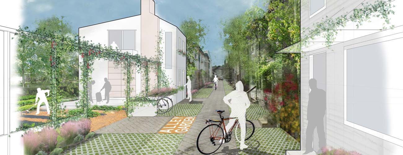
Alley Housing
Long thought of as a liability, alley housing can be renovated into small and affordable units lining a street with character and charm. Upper Lawrenceville is one of a handful of neighborhoods in the city with alley housing and the Study identified the opportunities to create shared open space gardens, bike areas and car parks to make the “alley commons” a desirable place for young professionals, families and older residents.
 Green Streets
As McCandless Street traverses through past hillside houses, flat residential and commercial areas, and industrial areas, it lacks a cohesive experience and is often used as a speedy shortcut. In addition to catching traffic from the side streets, it also retraces an original streambed and funnels stormwater from the surrounding streets. The Study proposes the a series of green infrastructure improvements on McCandless Street such as stormwater planters that use planters and tree wells to narrow wide streets at intersections, capturing water and calming traffic.
Work
Define the Center
As one of the longest continuous commercial corridors in the city, it can be difficult to create a critical mass of business traffic. This is especially true in Upper Lawrenceville, where there are vacant storefronts and properties create significant gaps in the identity and experience of the district. The Study identified that creating a center at the intersection of McCandless and Butler would help to define the district as activity radiates out from planned improvements.
Pop-Up! Fill-In!
Currently one of the defining factors of the Upper Lawrenceville stretch of Butler Street is that it has more vacant storefronts and properties that other areas of Butler. The Pop-Up! Fill-In! initiative is a program that works with property owners and potential tenants to encourage short term use and branding of underused spaces that later develop into long term tenure. The Study identified three innovative business development models that could be used to create energy (“pop-ups”) and maintain momentum (“fill-in”) for the business district.
Play
River Recreation
Riverfront access and recreation will help redefine McCandless Street as the corridor that connects residents and businesses to the river. The community envisions a park that serves neighborhood needs, including connection to regional bike trails, a small park, access for kayaks and canoes, and a floating barge pool that attracts seasonal visitors. The green stormwater infrastructure that defines McCandless Avenue gives the riverfront park its character and the overlook celebrates the improved quality of the water by returning water to the river that is cleaner than when it left the sky.
Green Space Network
The Green Space Network proposes to transform underused open space into a group of gardens, trails and parklets that better serve the community’s growing needs. Allotment gardens are proposed as part of an overhaul of the Duncan playground. Urban parklets are part of plan for public space to be developed as part of new development such as alley housing and renovations like the McCleary school. The community would also like to create a trail system in the adjacent hillside and cemetery to create a network of trails that connect new and existing green spaces.
